


So the time is approaching that I’ve got to make a decision as to when to head off to Oban, catch the ferry to Barra and set off along The Hebridean Way. I’ve mentioned the plan a few times on here and there’s even a dedicated page that you’ll find by clicking on the ‘cycles’ tab and the top of this page and choosing ‘2021: The Hebridean Way‘. What you won’t find there is any kind of day-by-day plan. That’s where this post comes in…
It might be useful to have the map on hand. This is the one that I have put together on Google Maps showing the route of The Hebridean Way, possible accommodation options, points of interest etc…
Let’s put it in a table. Note that the dates are simply for illustrative purposes. They may well change according to what the weather forecast says…
| Day | Date (tbc!) | Start | Finish | Cycling Distance | Transport | Accom. |
|---|---|---|---|---|---|---|
| 1 | 16/8 | Home | Oban (via Glasgow) | 10 km | Cycle / Train | Camping / Hostel |
| 2 | 17/8 | Oban | Barra | – | Ferry | Camping |
| 3 | 18/8 | Vaterssay | Barra Sands | 26 km | Cycle | Camping |
| 4 | 19/8 | Barra Sands | Linaclate | 64 km (inc. 10 km on ferry) | Cycle | Camping |
| 5 | 20/8 | Linaclate | Berneray | 68 km | Cycle | Camping |
| 6 | 21/8 | Berneray | Tarbert | 34 km | Cycle | Camping |
| 7 | 22/8 | Tarbert | Callanish | 61 km | Cycle | Camping |
| 8 | 23/8 | Callanish | Shawbost | 20 km | Cycle | Camping |
| 9 | 24/8 | Shawbost | Butt of Lewis | 38 km | Cycle | Camping |
| 10 | 25/8 | Butt of Lewis | Stornaway | 46 km | Cycle | Camping |
| 11 | 26/8 | Stornaway | Ullapool | – | Ferry | Camping |
| 12 | 27/8 | Ullapool | Glasgow (via Garve) | 51 km | Cycle / Train | Youth Hostel |
| 13 | 28/8 | Glasgow | Home | 10 km | Train / Cycle | – |
The devil is in the detail of course…
Day 1
The cycling bit here is at the very start of the journey; from my home to the railway station, probably the one in Huddersfield as it connects easily with the trains that head north to Scotland on Monday 9th August. The first off-peak train to Glasgow leaves Huddersfield at 9.38am and arrives in Glasgow at 2.02pm (changes at Manchester Piccadilly and Wigan North Western). There’s an alternative train that leaves Huddersfield at 9.46am and arrives in Glasgow at 2.32pm (changes at York and Edinburgh Waverley). Both are priced at £116.60 for an off-peak open return.
UPDATE: I think I will travel from Halifax instead. It’s the same price but only one change – in Preston – and the timings of that change are more favourable. There’s a train leaving Halifax on Monday 16th at 10.28am that arrives in Preston at 11.38am. That hooks up with the 12.02 from Preston to Glasgow Central arriving in Glasgow at 2.39pm.
There aren’t many trains every day from Glasgow Central station to Oban and none are direct. The best time would be the 4.25pm train that arrives in Oban at 7.42pm (change at Dalmuir). The Oban line is the one with the carriage that has been converted to take bikes (see update below). That would be useful… Cost for a single is £27.20.
UPDATE: Since I first published this post, Campbell Hutcheson (who became my unofficial Scotland advisor when I was cycling the Scottish leg of my round-Britain tour last summer…) has added some useful info about the trains to Oban:
“The direct rail link from Glasgow to Oban is from Queen Street Station, which is only a five-minute walk from Central Station. The route timetable offers plenty of choice.”
This might be a much better option (and I suspect it is the line that uses the bike carriages rather than the train from Glasgow Central). There are 6 trains per day to Oban, 2 are early and then these 4 later in the day:

Campbell also comments:
“The Premier Inn sits next to Oban Station, so that might be a cost-effective option. I’ve never been disappointed with the hotel chain’s service. As a born-and-bred Weegie, I wish you fair passage through my native city and best of luck with the island trip. As for the midgies, you’re on your own.” (End of update…)
Once in Oban there’s a campsite about 5km along the coast to the south west – Oban Caravan & Camping Park – but (here we go…) it is not currently open for tents due to the pesky virus! All of Scotland is now in ‘level zero’ when it comes to COVID restrictions. Notes on level zero as far as ‘holiday accommodation’ are as follows:
“All holiday accommodation (hotels, B&Bs, self-catering, hostels caravan and camping sites) can open in line with sector guidance for tourism and hospitality.
“In self-catered or other unregulated (unstaffed) accommodation, in-house socialising rules apply. In Level 0, a maximum of 8 people from up to 4 households can socialise in a private dwelling. Children under the age of 12 from these households do not count towards the total number of people permitted to meet.
“In public spaces within regulated (staffed) tourist accommodation, the rules about socialising in an indoors public place apply. In Level 0, a maximum of 10 people from up to 4 households can socialise indoors in a public place. Children under the age of 12 from these households do not count towards the total number of people permitted to meet.”
www.gov.scot
…but it does seem that many campsites and hostels have yet to return to normal when it comes to allowing visitors who, basically, need to use shared washing and toilet facilities. There’s a Scottish Youth Hostel in Oban. £60 for a private room (no dorms open…). May be worth the expense bearing in mind a late arrival.
UPDATE: Comment from Ian Muirhead on Twitter… (there’s another one further down the post)

UPDATE: The train carriages that carry bikes are called the ‘ScotRail Highland Explorer’ and there are more details about them on this page of the ScotRail website. Here is the timetable for the trains that have the bike carriage:


Day 2
The Caledonian MacBrayne ferry from Oban to Castlebay on Barra leaves the mainland at 1pm (check in by 12.30pm) and arrives on Barra at 5.45pm. The cost is a modest £15.55:

There are a couple of campsites just the north-west of Castlebay at Borve (4km). They are in the ‘wrong’ direction as far as the Hebridean Trail goes as it would mean returning south the following morning – a cycle of about 11km – to start the route at its official starting point on Vatersay. There appear to be no campsites on Vatersay itself but there’s always, of course, the wild camping option. Have a read of this written by a chap called Tom:

“Vatersay beach, the most Southern point of the Hebridean Way, provided my first night wild camping, though won’t be soon forgotten. The surprisingly warm turquoise waters bath spotless, white sands, which rise into tall grass providing adequate protection from the elements. The nearby Visitors Centre (when open) also allows explorers to indulge in their shower facilities.”
TomsTalesOfWoe.com
Perhaps this trip should really see me embrace the concept of wild camping in a way that I have never done before…
UPDATE:

Day 3
The start of the Hebridean Way! At last… Wherever I happen to have camped at the end of day 2, I am not the kind of person to miss out the start of a route simply because it might mean a few extra kilometres. At some point on this day – probably quite early as I don’t tend to hang around in the morning – I will travel to the Post Office on Vatersay as it is here where the route starts. More or less. There’s a beach just to the south of the official starting point called Bagh A’Deas. (Is this, perhaps, the one referred to by Tom above?) If easily accessible on a bike, that might be worth a visit but after that it’s a case of starting the plod along the Hebridean Way to the Butt of Lewis some 297km further north.
The suggested itinerary (suggested, that is, by Visit Outer Hebrides) has the end of the first section at a place called Daliburgh on southern end of the island of South Uist. This involves a 40-minute ferry from Barra to Eriskay with ferries leaving Barra as follows:

B = Sunday leaves at 8.55am)
However… there are a cluster of campsites at the northern end of Barra that may be good to make use of. Well, one of them at least. Barra Sands Campsite, Scurrival Campsite and Croft 2 are all a little way from the route of the Hebridean Way but only by about 6km or so. All three sites appear to be open. The views from Scurrival look particularly good but being so close together, perhaps they just have a better photographer on their staff. And by travelling to them, it would mean passing the famous Barra ‘airport’ which is actually a beach.
UPDATE: from Ian Muirhead again…
“There is a combined island hopper ticket that might save money and includes all the journeys you’re looking at. I think it’s this one.“
Day 4
So it seems more likely that the ferry to Eriskay (see timetable above) would be taken first thing on day 4. Probably the departure at 9.25am arriving on Eriskay at 10.05am. The rest of the day would be spent cycling the length of Eriskay (quite small) and South Uist (much longer). The suggested destination for the second day of the journey is a place called Clachan. I can’t see any campsites near Clachan but there is a site just over the water at the southern end of Benbecula. It’s called Otter’s Edge Campground and proudly proclaims on its website that “WE ARE OPEN”. (Wish they were all so unequivocal.) It’s near a place called Linaclate.
Day 5
Linaclate to Berneray. That’s a ride of 68 km according to bike directions on Google Maps which is curious. Yes, I’ve checked and the route suggested follows the Hebridean Way but, according to the authorities, it should be 44 km from Clachan (further south than Linaclate) to Bernerey. Very strange… Here is that suggested schedule:

It comes from a document you can download from VisitOuterHebrides.co.uk. Here is the link. In fact here is the document so you can see the whole thing without downloading:
Quite useful, but the question remains over the mysterious distances…
The good news is that on Berneray there is one of the three Gatliff Trust hostels. You can even camp in their groups. The bad news? They are still closed according to the website. It was last updated on July 2nd so perhaps things will change soon and they will reopen. They do make a point of saying that ‘it is impractical for anyone to camp in the hostel grounds‘ at the moment. Perhaps another night of wild camping beckons… Either way, let’s assume that I sleep soundly on the small island of Berneray, somewhere. (That said, in the second podcast referred to below, the podcaster Ian doesn’t have many kind words to say about the island of Berneray…)
Day 6
Berneray to Tarbert. 34 km according to the authorities. There’s the second of the ferries to factor in as well. It’s the Berneray-Leverburgh ferry across the Sound of Harris. Here’s the schedule:

Again, I suspect it would be the 9.30am ferry that arrives an hour later on Harris. There is a long caveat on the ferry website about tides on certain days resulting in changes to times of the ferry. Here’s the link if you are interested.
Tarbert is a town that sits on the bit of land that links the small bit of Harris to the big bit of Harris. I’m sure there are technical geographical terms to express that in a better way but I’m buggered if I know what they are. Here’s a map of the area showing the Hebridean Way:
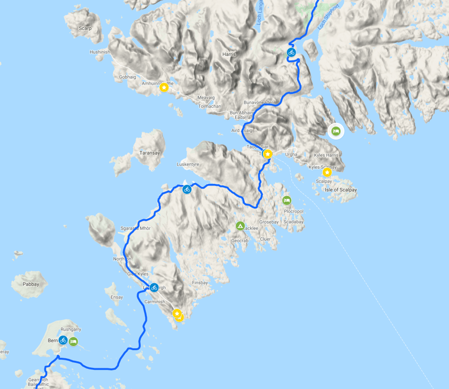
Tarbert is the place at the end of the line showing the route of a ferry back to the mainland. There don’t appear to be many camping options in or near the town itself. However, the West Harris Trust seem to have multiple places to camp along the coast prior to arrival in Tarbert. Here’s another map:

Taransay is the island just off the coast where Castaway was filmed.
So day 6 could be a little shorter than the 34 km listed but, checking Google Maps, they give the distance from Berneray to Tarbert as… oh. 34 km. I’m almost disappointed. That’s the distance from the ferry terminal at Leverburgh.
UPDATE: A few people – including Anne Lawther – have mentioned the ‘Golden Road’. This is what Anne had on say:
“The Golden Road from Leverburgh to Tarbet is far more scenic (in my opinion) than the official Hebridean Way on the west coast. Cycled both. Both good but Golden road wins hands down.”
I’ve added the ‘Golden Road’ (or what I assume is the Golden Road) to the Google Map. Here it is on the eastern side of Harris:

Taking this road it is 41 km from Leverbrugh to Tarbert. It would take me past Lickisto Blackhouse Camping.
But hold the front page! Searching online I have found this article on the Cycling UK website about ‘The sands of Luskentyre and the Golden Road, Isle of Harris’ which would suggest that the Golden Road is just the bit in the north-eastern corner of that map. The article refers to a ‘sharp right turn‘ that is signposted ‘The Golden Road‘. Below is the junction on Google Streetview, an image from 2009 which must pre-date the erection of the sign:

Elsewhere, on the website UndiscoveredScotland.co.uk, an article about the Golden Road makes the following comments:
“There is an alternative. The south east coast of Harris, stretching from Tarbert down to Rodel, is deeply indented by lochs and contains some of the rockiest low level scenery anywhere in Scotland. For much of history the many tiny settlements that dot this coast were accessible only by sea. But in 1897 a road was built along the coast, linking these settlements together. This east coast road is widely known as the Golden Road, apparently because of the very high cost of building it through this very difficult.
“The Golden Road is best tackled from Rodel. That way the sun (assuming nice weather) will be generally behind you rather than in front of you, making driving [!!!!] a fairly demanding single track road easier, and showing you the spectacular scenery in, literally, its best light.”
UndiscoveredScotland.co.uk
That would imply that the Golden Road is the entire road from Leverbrugh in the south to Tarbert in the north.
Day 7
Now, should I actually stick to the dates suggested in the chart at the top of this post, day 7 will be a Sunday. This might be relevant. Keep reading… I’ve just listened to a fascinating podcast – no, not The Cycling Europe Podcast (although that is also fascinating…) – from Visit Scotland called 100,000 Welcomes. Episode 7 is all about The Outer Hebrides and it consists of a chat between Scottish broadcaster Grant Stott (who has the perfect voice for a podcast all about Scotland) and a tour guide from Stornaway called Magaidh Smith. Here’s the blurb:
“This week Grant speaks to tour guide Magaidh Smith from the Isle of Lewis in the Outer Hebrides. WIth six generations of her family calling the Hebrides home, her unrivalled knowledge of the rich cultural history, traditions and communities of the Outer Hebrides makes for a fascinating listen. From Moon Gods and stone circles, to Neolithic history, clan battles and the Gaelic language – discover a wealth of incredible stories.“
Apple Podcasts
…and here’s the podcast itself on SoundCloud:
Actually, that’s not the podcast which refers to Sunday, but it is a fascinating listen. Well worth an hour of your time if you are planning a visit to the islands. The podcast that refers to Sunday is called Travel Tales From Beyond The Brochure, episode 22. Now be warned, the presenter, a chap called Ian from Sheffield who also goes by the name of the ‘barefoot backpacker’, does spend the first part of this episode reminiscing about his youth listening to the radio. Not altogether un-entertaining but irrelevant when it comes to The Outer Hebrides. Skip forward to 11 minutes 50 seconds into the episode to find the bit that is relevant. Skip forward to 22 minutes 34 seconds to listen to what he has to say about Sundays on the islands of Harris and Lewis.
So if you did listen, you’ll understand why day 7 of this trip (or the Sunday of this trip) might pose problems.
But what about the cycling? Well, Tarbert to Callanish – famous for its standing stones – is suggested. It’s 61 km. But if I’ve stayed at one of the campsites of the West Harris Trust, I’ll need to add on an extra 15 km. 76 km in total? Not impossible (I averaged 110 km per day back in 2013 when I cycled along the Mediterranean from Greece to Portugal) but I’m in no rush and my leisurely trip with the bike to the Yorkshire Dales last autumn brought home to me that there is more to cycling than long distances:
That was a bit of a tangent but it brings back good memories. Back to Harris & Lewis. Accommodation options between Tarbert and Callanish don’t seem to exist. Other than wild camping of course… At Callanish there is a campsite with ‘camping pods’ but they don’t allow tents on site. Which, imho, means it’s not a campsite. It’s called Callanish Camping. There are a couple of B&Bs if needs be. Perhaps by this point I will have embraced my wild side and wild camping along with it.
Day 8
Wherever I happen to have slept on the previous night, Callanish is clearly a place worthy of a pause in cycling so, rather than this been the final day of cycling to the end of the Hebridean Way at the Butt of Lewis, it would seem pragmatic – enjoyably pragmatic – to split the final suggested leg of the trip into two. Day 8 spent pondering the standing stones for a while then a shortish cycle up the coast to, say Eilean Fraoich campsite at a place called Shawbost. That would be only 20 km, perhaps more if I’ve wild camped somewhere south of Callanish.
Day 9
From Shawbost to the Butt of Lewis and the end of the Hebridean Way! I’m really not going to worry about accommodation options for this day. Surely something will turn up…


Day 10
Back to the functional job of getting home, but cycling on the Outer Hebrides is not quite over yet as I will need to travel to Stornaway to catch the ferry to Ullapool on the mainland. 46 km, about half of which will be retracing my steps south before turning left for the east coast of Harris and Stornaway. It’s a sizeable place (certainly by Hebridean measures) so not too much to worry about when it comes to accommodation. There is a campsite (which is open) called Laxdale Holiday Park on the northern edge of the town.
Day 11
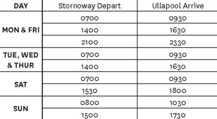
There’s a daily ferry that takes 2.5 hours and costs £10 from Stornaway to Ullapool:
There’s a Youth Hostel on the harbour front in Ullapool. I stayed there back in 2014. However… it’s looking fairly booked up (if the schedule proposed here is adhered to, I wouldn’t be able to stay there on August 19th as it is full.) Other options will be needed. There’s a campsite a little north of Ullapool called Ardmair Point Holiday Park. Lots of time on this day to sort things out, especially if I catch the early ferry.
Day 12
Ullapool is not on the train network. Back in 2014 when I cycled along the north coast of Scotland east to west and then down the west coast north to south (obviously…) I stayed, as mentioned, in Ullapool but continued along the west coast, over the bridge to Skye and then caught the ferry back to the mainland at Mallaig. From there I could catch a train back to Glasgow, which is what I did (along with the Harry Potter fans…). This time I think I will head inland along the A835 to Garve when there is a train station on the line to Inverness. An A road? Really? (I hear you cry…) Well this is northern Scotland so it shouldn’t be too bad. Indeed browsing a few random points of the A835 between Ullapool and Garve reveals very few cars and some spectacular landscape:


So it should be a nice 51 km cycle, no?
There are four trains a day from Garve to Inverness:

Those are the trains on Friday 20th August (weekdays). They are at exactly the same time on Saturday. On Sunday the trains leave Garve at 11.57am and 4.51pm (should my schedule have shunted forward a little). I would try and connect with a train to Glasgow if time. There are around 11 trains per day to Glasgow but the train does take on average 4 1/2 hours to get there… Youth Hostel in Glasgow? £30 for a room and the availability is currently looking much better for the whole of August than it’s looking in Ullapool.
UPDATE: I’ve just been re-reading my entries on CyclingEurope.org from when I cycled in Scotland in 2014 and – much to my surprise – I have discovered that I actually cycled from Ullapool to Garve on that trip. I had thought that I continued along the coast but clearly I didn’t… Here’s what I wrote at the time:
UPDATE: From David Sinclair on Facebook who says it’s “…worth investigating the train back from Culrain/Invershin instead of Garve. Generally a much quieter road from Ullapool to there and you get to see Assynt too. The A835 isn’t the best for cycling, it’s a fast road!”
Day 13
Glasgow to home via train using the open return ticket I purchased on the way up.
That’s it! Any thoughts?
Header image credit: VisitOuterHebrides.co.uk
UPDATE: Lots of comments on an Instagram post I published a few days ago…
Since 2009, CyclingEurope.org has established itself as a valued, FREE cycle touring resource. There’s now even a podcast, The Cycling Europe Podcast. If you enjoy the website and the podcast, please consider supporting the work of CyclingEurope.org with a donation. More information can be found here. Thanks if you do!
Catch up with The Cycling Europe Podcast:
Discover more from CyclingEurope.org
Subscribe to get the latest posts sent to your email.

Andrew – thanks for planning next years holiday for me. Look forward to hearing all about it. Re camping at Ullapool – there is a campsite right in the centre of Ullapool called Brookfield Holiday Park. Loads of tents when I stayed there. Guy comes round in the morning to collect overnight fees. Great views of ferries.
Thanks Jennifer. That’s noted. Have you listened to the new podcast yet?
Looks like a great trip.I’m always too wary of poor weather in Scotland, especially camping.
Have you ever looked at Split Ticket for your train tickets. Looking very quickly at your journey days/times I reckon you can get the same tickets for about £35-00 cheaper
https://book.splitticketing.com/default.aspx
The price I quote in the article Paddy is for an open return which gives me the flexibility I require. I dare say I could probably knock a few quid off the price if I spent some time on ticket splitting sites but I’m not sure it is worth the effort. Thanks for the suggestion however 🙂
The direct rail link from Glasgow to Oban is from Queen Street Station, which is only a five-minute walk from Central Station. The route timetable offers plenty of choice (see link).
https://www.scotrail.co.uk/scotland-by-rail/great-scenic-rail-journeys/west-highland-line-glasgow-oban-and-fort-williammallaig
The Premier Inn sits next to Oban Station, so that might be a cost-effective option. I’ve never been disappointed with the hotel chain’s service.
As a born-and-bred Weegie, I wish you fair passage through my native city and best of luck with the island trip. As for the midgies, you’re on your own.
Thanks for that Campbell. Much appreciated. Yes, the train from Queen Street does seem a far better option!! I’ve added your comments to the main post in an ‘update’ so I don’t forget. Midges? Mmm… 🙂
Cheers, Andrew. Had a look at Premier Inn prices and they’re a good deal higher than normal. Now there’s a surprise.
Sounds great, loved it when we did it (we didn’t camp).
As you’ve gathered, Sundays are different on the islands, but places to eat or shop can be limited at any time. Best advice – top up at every opportunity you can.
If you have time on North Uist, and the weather is clear, then a detour to the St Kilda viewpoint is well worthwhile. But, you can say similar about so many places up there.
When you arrive on Berneray, you’ll pass the ferry ‘terminal’ straight away. As timetable can be affected by the tide, it’s worth stopping to check ferry times.
Generally, I’d just say take your time and enjoy
Thanks Steve. Very good points, especially regarding the ferry terminal. Thanks 🙂
Sounds a good plan, it’ll give you plenty of time to see stuff along the way. The OH is a place to savour, no point in whizzing along and not stopping. The farther north you go, the less which is open on a Sunday apart from Stornoway. Make sure you’ve got contingency re the ferries if the weather closes in then ferries can be cancelled or rescheduled, possibly by cancelling the last ferry but including an earlier time.
Thanks Peter. Useful comments 🙂